
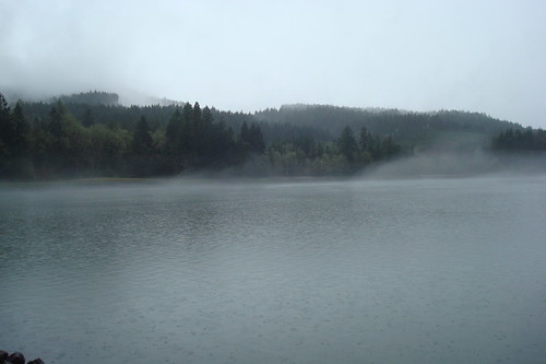
It was wet but (almost 60 degrees, WHAT?) we stood outside for a bit and looked out at the reservoir. It was all misty and pretty.
Before we left the house I had peeked at Google Maps quickly to find some roads to check out. One of the weird things out here is that you can't just go out for a drive and always expect there will be multiple routes to get home. Especially if you are heading east because at some point you are probably going to hit a pass and be in the mountains.
I found a road that looked like it just ran along the shore of Lookout Point Lake, which is what we would have been driving along if we had stayed on 58, just the opposite side. I couldn't really see any point where it would be easy to cross back over to 58, but we decided to try it out anyway.
It was so pretty, despite the rain and clouds and wasn't really what I expected. I thought it was going to be a lower road that just went along the shore but we were pretty high above in the trees. The road twisted and turned I kept trying to peek through little clear spots down to the lake and I kept noticing that all along the shore were tree stumps. We eventually stopped at a boat launch area and got out. We walked a ways down long boat ramp and just looked around for a bit. Tree stumps everywhere!
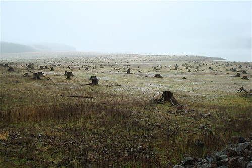
Maybe it was the mist and fog and rain, but for whatever reason, this was such a bizarre site to me. We couldn't see an end to them in either direction and it kind of creeped me out!
We got back in the car and we were going to continue down the road but there were signs that said the pavement ended. We continued down a little further but it turned to gravel and since we didn't know at what point it would, if at all, turn back to pavement, we decided to turn around. When we got home later I looked at a map and it turned out we barely even made it halfway down the road! It wasn't too far a drive away from Eugene, so I think we are probably going to try and go back on a day when it's not so wet.
When we got home Adam made giant burgers for lunch. Giant burger + having taken Bonine so I wouldn't get carsick = Me passing the eff out for an hour or so after lunch. It was kind of an accidental nap situation.
But anyway! We will be back for you, N. or W. Boundry Road! (I think the map and the actual road said two different things)
I would've felt a bit creeped out by all those tree stumps, too. So neat that you thought to take a picture of it. It's really a shame trees weren't replanted. I wonder why they were all cut like that...
ReplyDeleteWe were thinking that it probably had to do with it being a man made lake? Not sure, really! I'm glad I took some pics too!
ReplyDelete